ET & Precipitation
Access monthly evapotranspiration and precipitation data to track water consumption and natural inputs across the basin.
Supporting sustainable groundwater management through voluntary fallowing and transparent data insights.
Harnessing high-resolution satellite imagery and groundwater monitoring to provide a comprehensive view of basin health and water usage.
Access monthly evapotranspiration and precipitation data to track water consumption and natural inputs across the basin.
Identify crop types and distribution patterns using advanced satellite classification to understand land use trends.
Monitor aquifer health through instrumented well data, providing critical context for sustainable pumping.
Explore comprehensive spatial data including GSA boundaries, parcels, farming units, and Williamson Act properties.
Create an account and start enrollment online. Complete self-certification and add your contact information. Your progress is saved as you go.
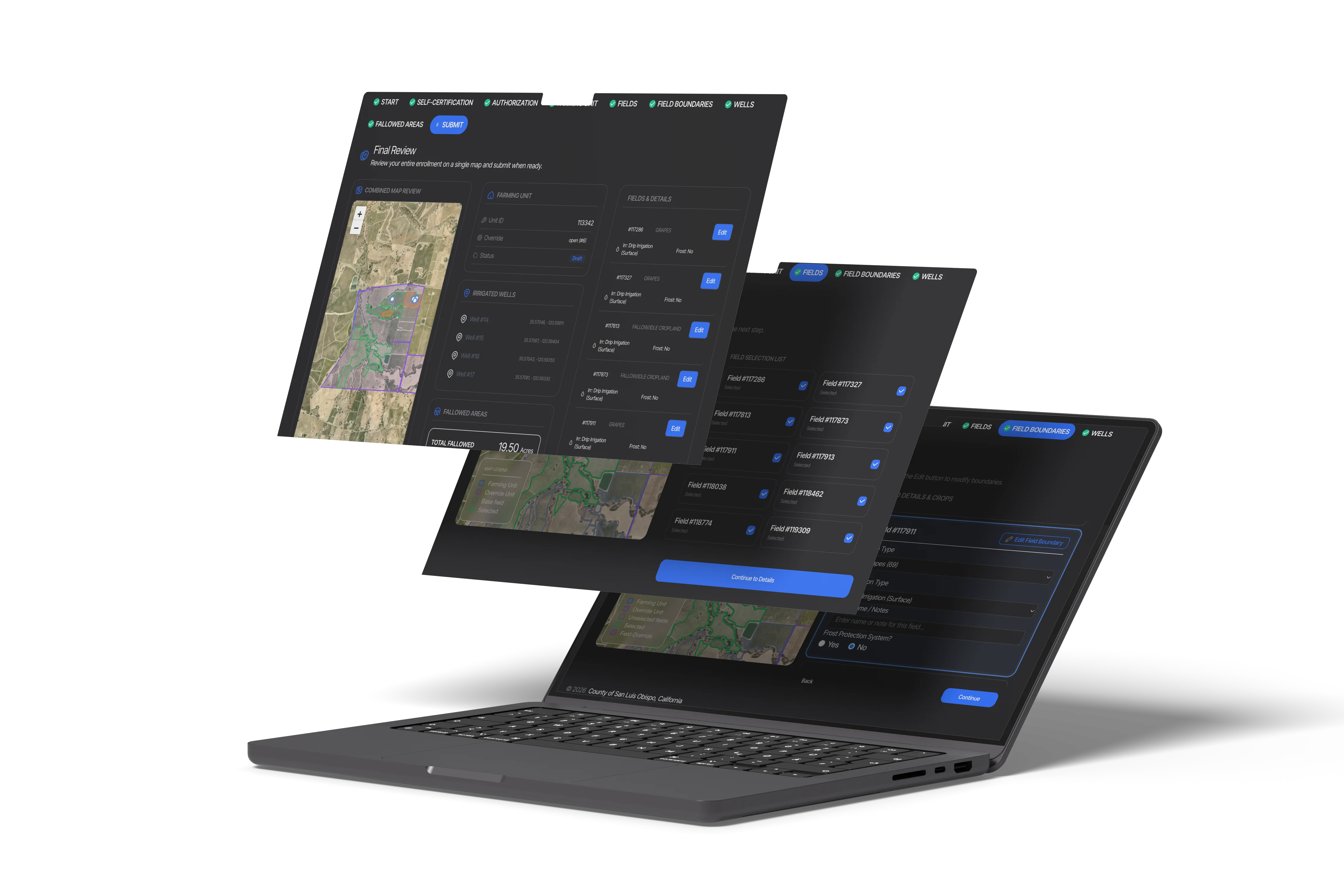
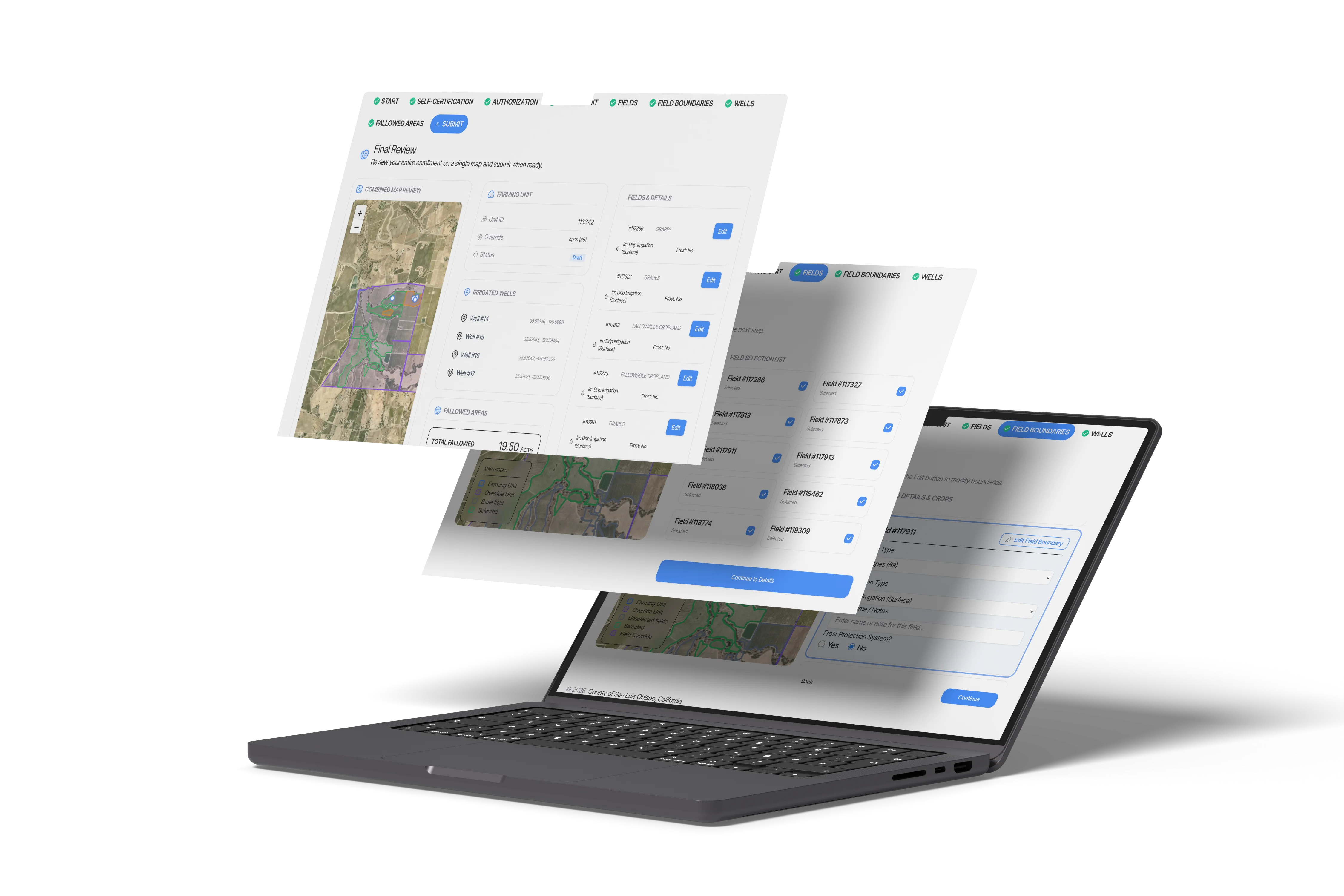
Use the map-first, GIS-based interface to confirm or claim your farming unit, add crop and irrigation details, mark wells, and draw fallowed areas. You can request boundary corrections when needed — our team will review them while you continue.
Access monthly ET data, precipitation, crop mapping, and other relevant basin datasets for your enrolled fields. Fallowed areas are screened automatically; we'll follow up if anything needs review.
The Fallowed Land Registry Platform serves agricultural irrigators, County and GSA administrators, and public stakeholders—each with tailored access and capabilities to support sustainable groundwater management.
Register fallowed lands and track water savings with secure PIN-based access to your farming unit data.
Document and verify fallowed lands, evaluate basin impacts, and manage enrollment data.
Access basin-scale statistics and transparency data to understand groundwater management trends.
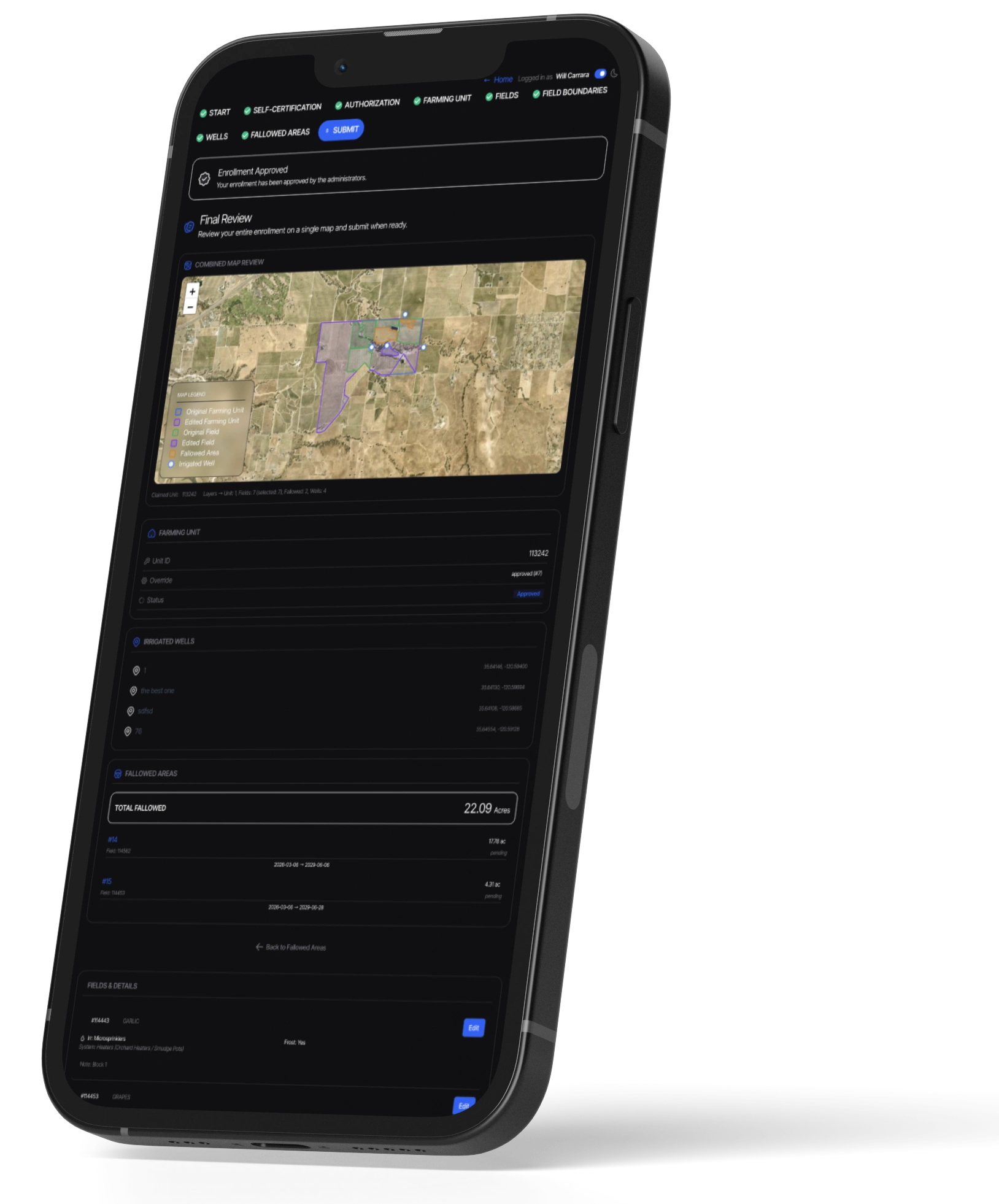
Most agricultural mapping tools are designed for desktop computers. This platform was built to work just as well in the field as it does in the office. View high-resolution satellite imagery, map fallowed areas, and check basin metrics directly from your phone or tablet.
Map in the field: Draw or adjust field boundaries while standing right on the property.
Easy-to-use layers: View important GIS data layers designed to work smoothly on phones and tablets.
Instant updates: Anything mapped in the field is immediately available to administrators and basin managers.
Find quick answers to common questions about the Fallowed Land Registry Platform.
Growers who enroll in the Registry would receive the following benefits:
No. Individual enrollee information is private and proprietary. Public access includes only basin-scale statistics and generalized information. Enrollees can only access their own farming unit data through secure authenticated accounts. The platform maintains strict privacy protections to ensure user data separation.
Public users can access basin-scale statistics and generalized information including monthly ET (evapotranspiration) data (total and net), monthly precipitation, crop mapping and crop type information, and comprehensive GIS layers. Individual enrollee data remains private and is not accessible to other users. Groundwater level data will be available in a future release and is not yet accessible to users.
The platform integrates high-resolution datasets from local, state, and federal agencies to provide a comprehensive, science-based view of basin health and water usage.
GSA Administration & Local GIS
Groundwater Levels & SGMA Data
Satellite-based Evapotranspiration
Crop Mapping & Soil Surveys
Hydrological Monitoring
Remote Sensing & Earth Observation
Geospatial Analysis Platform
Land IQ, FEMA, & Local GSAs
The Fallowed Land Registry Platform is developed and managed in collaboration with County of San Luis Obispo Groundwater Sustainability Department and the Paso Basin Groundwater Sustainability Agencies to support voluntary fallowing and sustainable groundwater management.
Groundwater Sustainability Agency
Groundwater Sustainability Agency
Groundwater Sustainability Agency
Subscribe to receive updates about new data releases, platform features, workshops, and important basin information.
Monthly updates
Workshop announcements